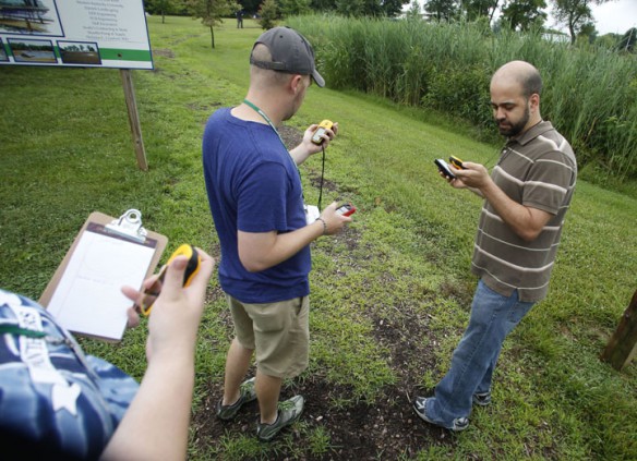
Frankfort High School geography teacher Shane Hecker compares his coordinates from a GPS unit to the ones from the Map My Run app during the Kentucky Geographic Alliance Summer GIS Institute. Photo by Amy Wallot, June 18, 2013
By Susan Riddell
susan.riddell@education.ky.gov
Location. Location. Location.
That’s what several Kentucky teachers learned about recently at the Kentucky Geographic Alliance’s (KGA) Summer Geographic Information Systems (GIS) Institute.
More importantly, they also learned how to transfer their new knowledge of GIS practices and lessons back into their own classrooms for students this coming school year.
“That’s what we’re here for,” said program facilitator Scott Dobler, a geography professor at Western Kentucky University (WKU) and co-director of KGA. “We work on mapping areas, and we link it to teachers’ curriculum that they already have. I basically show them how maps can be integrated into content.”
The GIS Institute is a three-day event for teachers of all grade levels. Participants who finished the recent program will attend follow-up sessions in November and April. During these follow-ups, teachers will present ways they used the GIS technology with their students, and talk about their findings. Teachers also are expected to present course curriculum to fellow teachers and other faculty members at their school.
Charles Hall, social studies consultant for the Kentucky Department of Education, said that KGA and several professors from WKU have been instrumental in developing GIS workshops for teachers that “focus on some very innovative approaches with GPS technology for the 21st century. These lessons use technology that addresses college and career readiness of 21st century-learners,” Hall said.
Dennis Millay, a science lab teacher at East View Elementary (Daviess County), is “a big proponent” of outdoor education.
“When it integrates math and science like what we’ve been learning, it’s great,” Millay said.
Millay met Dobler at a Student Technology Leadership Program (STLP) event last year, and while he had some prior knowledge of GIS, Dobler recommended the summer institute to him to help him transfer that knowledge more into his classroom and not just use it to judge at competitions like STLP.
“It’s wonderful to get these opportunities because the world is changing, and the way we teach our kids has to change as that happens,” Millay said. “This is a great way to gets hands-on learning ideas, and that’s what it’s going to take. The old way isn’t going to cut it. Worksheets aren’t going to work.”
During the event, Dobler led the teachers through the experience by showing them how to use GPS technology to mark the boundary of the wetlands at Lost River Cave. After showing the teachers how to use the GPS devices, he broke them off into groups that marked certain points of the boundary. They later compared GPS readings from a GPS unit to the Map My Run app.
Dobler talked to the group about potential problems for the lesson like accuracy, and he also worked with them on ways to enhance a lesson with students based on what type of student handles a specific job within the assignment. He noted the importance of having certain students as group leaders, recorders or safety monitors.
Who does what may vary based on grade level of the class getting ready to check for coordinates.
T.K. Stone Middle School (Elizabethtown Independent) science and social studies teacher Katie Davis said her class would benefit more from having more students doing the hands-on work.
“It keeps them on task,” she said. “The more hands I can get doing something, the more success and fewer problems I’ll have with my kids.”
For Kathy Howells, a 6th-grade teacher at Jessie Clark Middle School (Fayette County), her students would benefit from trading off jobs.
“My students,” she said, “would be assigned a role then look as someone else’s and say, ‘Why can’t I do that?’”
Practically any lesson using the GPS technology can be adjusted to fit the classroom, Dobler said. The fun part for Dobler now, is watching the teachers take the standards-based GPS curriculum, and integrating it within their lessons.
Millay said he will likely create a lesson that has students build a disc golf course model while Howells said she hopes to take students to nearby Raven Run Nature Sanctuary for a social studies unit.
Regardless of what type of lesson a teacher creates, Dobler said one could be made in practically any STEM area.
A science lesson might involve studying sinkholes, tree categorization or stream chemistry.
Mathematics and mapping go hand in hand, Dobler said, with geometry elements like quadrants, latitude and longitude. Students can calculate slope of the side of the valley or the depth of a sinkhole.
“Calculus is used to take measurements to model flow,” Dobler said.
Mapping also can be incorporated into social studies lessons dealing with economic tourism, Civil War encampments, Paleo Indian artifacts and big band era speakeasies, Dobler noted.
“But, with mapping, you can easily engage any content area that you have the imagination for,” Dobler said.
Teachers can map out short stories. “James Still (River of Earth) has a lot of descriptive stories. So does Lynnwood Montell (Don’t Go Up Kettle Creek: Verbal Legacy Upper Cumberland),” Dobler said.
Other mapping examples he gave include mapping:
- a historical narrative like Lewis and Clark moving out west
- different music styles like New Orleans jazz moving up the Mississippi River
- food preferences like barbecue styles in Kentucky
Teachers who are interested in creating mapping lessons don’t need to spend a lot of money on the technology, Dobler said, and teachers in all parts of the state can take advantage of it. All it takes is a teacher (or classroom student) with a smartphone. KGA has GPS units to loan, too, he said.
“If teachers can get a signal with their smartphones, they have enough technology to begin a rewarding activity with their students,” Dobler said.
 teacher Shane Hecker and Hopkinsville High School (Christian County) teacher Joe Parrino use GPS to mark the boundary of the wetlands at Lost River Cave during the Kentucky Geographic Alliance Summer GIS Institute.Photo by Amy Wallot, June 18, 2013")


, Western Kentucky University, Jessie Clark Middle School (Fayette County) and Muhlenberg County High School respectively. Photo by Amy Wallot, June 18, 2013")
MORE INFO …
Scott Dobler, scott.dobler@wku.edu, (270) 745-7078
Leave A Comment