
Brooke Whitlow, instructional technology coordinator at Hardin County Schools, explains how her students made a Google Cardboard virtual reality headset during a session at the Kentucky Council for the Social Studies conference. Brenna R. Kelly, Sept. 30, 2015
By Brenna R. Kelly
Brenna.kelly@education.ky.gov
Call Brooke Whitlow the crazy Google lady. Really, she doesn’t mind.
Whitlow, a certified Google for Education trainer, travels the state teaching fellow educators how to use Google Apps for Education in the classroom.
“I’m completely obsessed with these tools,” Whitlow said. “People actually do call me the crazy Google lady.”
Whitlow, instructional technology coordinator for Hardin County Schools, recently introduced teachers to two new Google tools at the Kentucky Council for the Social Studies conference in Erlanger.
The features, My Maps and virtual reality, allow students to experience social studies content in ways that aren’t possible with a textbook and a lecture.
My Maps lets users build their own maps with place markers, photos and videos. There are also tools for measurements, such as distance and area, and options to add directions for driving, walking or bus routes.
“You can change your base map to be whatever you want it to be. It can be map, satellite, terrain or just land masses,” Whitlow said.
My Maps is free and available to anyone with a Google account. It also includes a share feature that allows teachers to share a map with their students so students can work on the map together. The feature is even easier to use if schools have Google Apps for Education and use Google Classroom, she said.
In Kentucky, 65 percent of the state’s 173 school districts use Google Apps for Education, said Marty Park, the Kentucky Department of Education’s (KDE) chief digital officer. KDE is frequently helping more districts integrate the technology, he said.
“The Google ecosystem is easy to use and it is obvious that they heavily rely on great teachers such as Brooke to help guide and lead their next round of digital learning innovations,” Park said. “Our learners should make stuff, and Google Apps help students connect, collaborate and share what they’ve made.”
Whitlow said one of biggest benefits of using Google is that students can work together in real time, she said.
“With My Maps, the idea is to create a map in a collaborative environment,” she said.
For example, students could use the tool to map the westward expansion or follow the trail of explorers Lewis and Clark, said Whitlow, who previously taught 6th- and 8th-grade social studies.
My Maps can pull in spreadsheet data — such as a list of cities or addresses — and automatically plot them on a map.
“You can import any data from anywhere, as long as that data is in a spreadsheet,” she said.
With measurement tools, teachers can explain map projection, the reason some land masses look bigger on a flat map than they actually are, she said. To illustrate the point, students can compare the size of countries, states or bodies of water.
“Students are going to think this is awesome,” Whitlow said. ““How powerful is that for them to be able to see that they can do this?”
Students also can create interactive book tours with the tool.
“Put the students in the setting of the book and allow them to map out the locations or look at the land forms,” she said.
Another way to use My Maps is to create maps as part of quizzes or starting points for discussion, Whitlow said.
For example, Whitlow first created a Google Form asking which battle was the turning point of the Civil War. Each participant logged an answer. Those answers were recorded in a Google Sheet, then imported into the My Map and locations of the battles automatically were located on the map.
And because the participants’ names were attached to the answers, she could call on them to explain their choice. Donnie Piercey, a 5th-grade teacher at Eminence Independent, created a tutorial on turning spreadsheets into maps.
Piercey, who is also a certified Google for Education innovator and certified Google for Education trainer, used the tool with his students to plot the pilgrim’s journey to the new world and map the land bridge theory.
While easier for schools that have devices for all students, the tool can be used even if there’s just one computer in the room, Whitlow said. A teacher can set up a computer station and each student can log their answer on the way into class, she said.
“The possibilities are limitless,” Whitlow said.
While My Maps can help students understand the places and events they are studying, another Google tool can take them there – virtually.
With Google Cardboard, students can walk around Grand Teton National Park in Wyoming, explore Tibet, visit the Eiffel
Tower in Paris or ride a roller coaster.
“If you are struggling to engage the unengageable,” said Whitlow, “let me tell you, this is your ticket right here.”
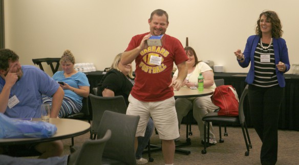
Garrard County Middle School teacher Greg Hammond uses the Google Cardboard virtual reality headset to ride a roller coaster. Brenna R. Kelly Sept. 30, 2015
The virtually reality headsets are made of cardboard with a smart phone inserted into the device. Students launch a virtually reality app or Google street view and then look through the cardboard to take a 360-degree tour.
While the cardboard kits can be bought online for a few dollars a piece, Whitlow recommends having students build the headsets.
“This is cafeteria cardboard, probably some canned corn came in these,” said Whitlow, holding up the headset her students made.
With some cardboard, 12 sets of bi-convex lenses she bought from Ebay for about $6 and instructions. Whitlow’s students created the headsets.
“I cannot tell you just how proud they were,” she said. “Of course, their favorite part of building the cardboard was taking it around to their teachers and watching their teachers use it.”
The database of virtual reality experiences is growing quickly, she said. Recently, The New York Times delivered Google cardboard to all of its Sunday newspaper subscribers for the launch of its virtually reality form of storytelling.
Google also is expanding its virtual reality offerings for schools through Google Expeditions. Though not yet available in Kentucky, Google Expeditions will allow teachers to take a class on a virtual field trip to more than 100 locations.
Google is rolling out the technology through its Google Pioneer Expeditions program, which provides the technology to schools. Google is visiting schools that show interest in the program. The sign up asks the school to have at least six teachers interested in participating.
Garrard County Middle School teacher Greg Hammond said he’d love to bring virtual reality to his 7th-grade social studies class. During the social studies conference session Hammond used the headset to ride a virtual reality roller coaster.
“Think of all the places you could tour on that. I think the kids would literally love it,” he said. “That would get their attention more than anything.”
MORE INFO …
Brooke Whitlow Brooke.Whitlow@hardin.kyschools.us
Leave A Comment